Categories
canada general hiking moosling snow

Mount St Piran: Yellow larches and snow

In larch season in the Rockies it’s pretty much obligatory to get out hiking. In general, September is hiking and trail running season. Tanya had invited us out to head out to hike the Devil’s Thumb, but once we all got to the Lake, the decision was made to go and do a proper summit – Mount St Piran it was. It was even in Kane’s Scrambles in the Canadian Rockies book!

First up is easy highway-style trails, the only challenge is traffic management as you hike in among so many other people.

But after we hiked past Mirror Lake at the foot of the Little Beehive, and past the turnoff to Lake Agnes, the crowds started to thin out.

As we started switch-backing up to the small saddle below the summit of Mount St Piran, it started to get snowy.  Well packed at first, but then increasingly slippery.

At the saddle, we finally met up with a group (from Rocky Mountain Adaptive?) who were helping get someone with a disability get to nearly the summit of Mount St Piran in one of their ‘TrailRider’ adapted one-wheel rugged weelchairs.

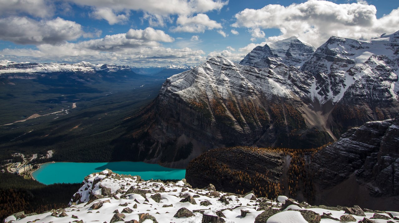
At the mini summit we paused for some photos and jumping, with the view down to Lake Louise below, looking resplendently turquoise.

Then it was onwards and upwards. Not far to the summit now!

The combination of cumulus clouds in the blue sky, snow-capped mountains, yellow larches, snowy terrain and Lake Louise were wonderfully beautiful. Also, hurrah for brightly coloured outdoor clothes – it makes for great photos.

The trail was much less well-packed to the summit, but it wasn’t far at all. It was a bit disconcerting though, as it was so poorly packed that you could still punch through the snow to a big talus hole.

Summit! And the wind had mostly died down enough that it was actually pretty pleasant. Amazing views, I can’t believe we’ve hiked so little here before (put off by the big crowds at the lakes below).

Then, to get down again, we’d decided to do a loop – back off the back of the mountain and down past Lake Agnes.

And because it was so beautiful, here are far too many photos from the descent.

As the terrain got steeper, it became more and more challenging.  Slippery. A lot of us slipped over at one time or another.  The boy decided he was better off with glissading the whole way, and thought the whole thing was amazingly fun, and way better than normal trails.

Glissading!  Thank goodness for waterproof pants!

We were hopeful that once we hit the saddle and left the snow, that it would be easier. But it was still tricky ground. Steep and loose, we switchbacked to and fro and I tried hard to convince the boy that he wasn’t allowed to just keep sliding down, as much as it might be really fun.

A few mountain goats hovered around on the slopes (not literally, although that would be awesome) – and watched us as we hiked by them.

Then finally, the terrain flattened out, and then we were at Lake Agnes, and back into the hiking crowds and larches.

The descent from there was fairly fast. And now the boy has two (the very easiest two I think) of the Kane scrambles under his belt.

And the added benefit of Lake Louise? There are plenty of pokestops and pokemon hanging out there if you’re hanging out waiting for people to arrive.

Distance: About 14.5km
Elevation gain: Around 900m
Time: About 6.5 hours
Figures in the map linked below are a little off, as we forgot to turn on the GPS straight away.

Categories
canada general trip reports

how to nearly hike up lawrence grassi peak

Step One

Park in the Goat Creek carpark, up above Canmore along the Spray Lakes Road. Walk up the hill opposite the carpark, over the bridge, past the trail up to Ha Ling, then along the road next to the canal for twenty minutes. Walk past rock cuts. See inukshuk and flagging in trees and follow faint path with more flagging up into the forest.


Looking back towards the parking lot from the start of the trail


Step Two

Reach drainage, do not cross it (unless you wish to try failing to hike up South Lawrence Grassi). Follow along it for a hundred metres of so then head back up left into the trees, steeply. And more steeply. Hit a few snow patches.


The drainage


Step Three

Reach the tree line. Start scrambling up the scree slope. Notice increasing presence of snow.


Breaking onto the scree slope


Step Four

Keep going up the ridge as it narrows, and narrows and narrows. Scramble over some dragon’s back ridge formations. Slide around on the snow a bit. Spot the summit cairn off in the distance.

Step Five

Get scared when the ridge starts getting steeper and narrower, and the cliff-type drop-offs get closer and closer, and amounts of scree and snow surface underfoot remain consistently high, and the weather is closing in and looking cloudy, and it starts to snow on you a bit, and you realise you didn’t tell anyone where you were going because it was just an afternoon hike.


Looking back down the ridge


Step Six

Turn around and go back down. Justify your decision as thoroughly sensible all the way down. Glare at the sky that turns nice and blue and sunny.

Categories
canada hiking trip reports

almost entirely unlike the edge of a knife

Mount Lady Macdonald – with an altitude of 2,606 m (8,550 ft) gives a 1200 metre elevation gain hiking from town. It was named in 1886 after Susan Agnes Macdonald, wife of Sir John A. Macdonald, the first Prime Minister of Canada (this is what wikipedia claims anyway, but there are all sorts of made-up things slipping in there these days, we all know Canada doesn’t even have a Prime Minister).

A typical 9 o’clock start had us leaving the house around 10 (we being Siggs and I, not Alex, who is stuck doing 14+ hour days at work this weekend), and walking towards Lady Mac – along a cunning short cut that actually forced us to walk uphill, and then ended up being tantalisingly close to the path we wanted, without actually reaching it. So we had to walk downhill again.

With the sore legs of people who had spent yesterday doing silly things (a 60km bike ride and hiking up Cascade mountain respectively), we hit auto-pilot on the way up, and told our legs to shut up and just keep walking.


Looking up Mount Lady Mac from the abandoned teahouse


We reached the teahouse and begun some heavy duty snacking. You could probably have even called it lunch, but for the fact we had a second one a few hours later. And the teahouse isn’t so much a teahouse as an unfinished wooden construction with lots of burn marks from where teenagers with no self-preservation have been lighting fires ON the teahouse using wood FROM the teahouse. It does provide a nice viewing and lunching platform though.


Following the teahouse there was a thankfully short slog up a scree slope until we reached the *dramatic chords* KNIFE-EDGE RIDGE. This was where I left Siggs, who has far too much common sense to be ignoring the fact she’s on a very skinny bit of rock with a definite cliff on one side, and a very steep slide on the other. There was only a light breeze, so the scramble across was actually really fun – there’s no technical difficulty to it, just the difficulty of ignoring your brain going ARGH, MY GOD IT’S A CLIFF, WE’RE ALL GOING TO DIE! Thanks to climbing I’m accustomed to my brain’s panicked warnings of impending doom. Although I didn’t stop to get my camera out along the way – I’m coordinated when it comes to not dropping me off a cliff, I have a bad track record when it comes to cameras and cliffs however.


Looking back along the ridge from the summit (this photo doesn’t really do justice to the steepness either, it’s really quite narrow at the top, though you can spend a lot of the time with your hands on the top of the ridge, walking your feet along holds on the slopey non-cliff side)


So I hit the summit – finally, that ridge seemed to go forever. Maybe it’s about 150 metres? I had Siggs at the start of it as a reference point, and she was certainly a distant blob. The journey back was quicker and easier, as I spent much less time going “Am I at the summit now? Nope, this isn’t it, maybe it’s that next bit.”


We sat at the top of the scree slope and looked down at the teahouse, helicopter pad, and Canmore while enjoying a second lunch. Followed by interminable plodding back down a path that seemed a lot less steep than it had done on the way up, and gradual removal of layers as we hit the warm valley air.