Categories
bikes canada general moosling trip reports

Our first bike-packing adventure: Jumpingpound Ridge

We’d been hoping to get out on a few overnight trips this summer, but our options had been limited by the flooding in June. Thankfully Kananaskis had finally opened up a little, and so we set on Jumpingpound Ridge as a likely destination.

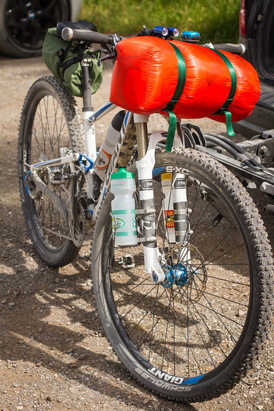
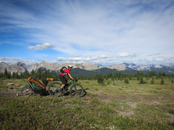
Here’s my faithful steed all kitted out for the ride. Thermarest strapped under saddle, all our sleeping gear strapped onto handlebars (with some dodgy home-made straps we knocked up). Extra water carrying capacity on front fork. We both wore hydrapacks to carry our spare clothes/extra layers plus a few other bits and pieces.

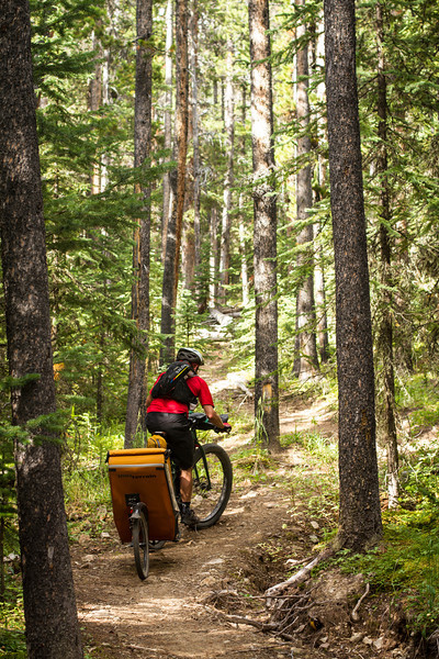
After unloading and packing at the Dawson Recreation Area, it was off down the Powderface Trail – closed to public vehicles at the moment, as it’s being used by Shell while their usual access road is still inaccessible post-flood. It made for a rather pleasant ride, as there were hardly any vehicles driving past and creating huge lung-coating dust clouds. As a result we could actually enjoy the wildflowers and small animals hopping about the place, squeaking furiously at us.

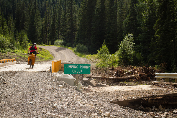
There were a few new bridges along the road though, it hadn’t escaped the flooding unscathed – here you can see the old bridge off to the right:

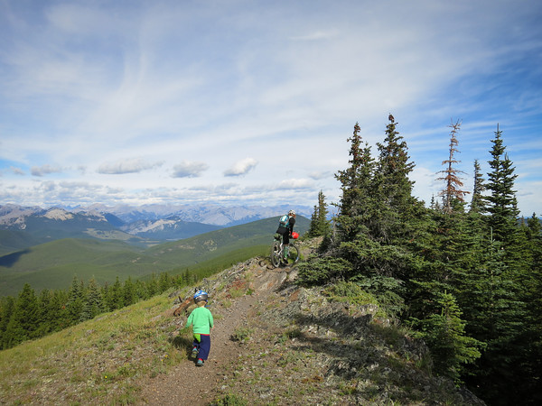
After our quiet gradual uphill along the road, we turned to the east, and started climbing up the Jumpingpound Summit Trail. It’s the shortest path to the summit, and also the easiest.

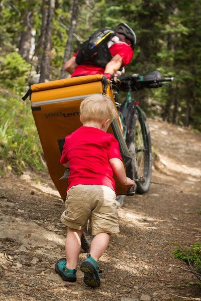
Nontheless, some pushing was required. The Moosling was booted out of the trailer and helped push Papa up the hill.

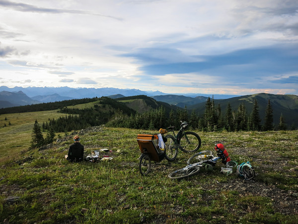
We had dinner on the ridge, just below the summit – just some pasta combined with dehydrated meals. Not fancy, but nice and warm.

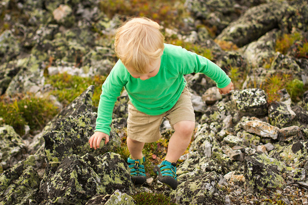
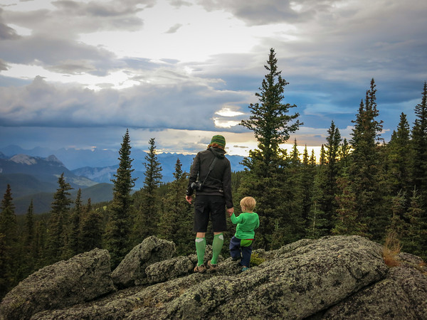
And we did a little rock climbing.

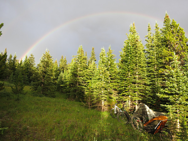
As we ate, the weather had started to get a little wild. The wind was picking up, and there was rain threatening from the west. We beat a hasty retreat down into the trees, and set up camp in time to be rained on for a while. The shower was short-lived, and we emerged from our tent to a rainbow!

After a little exploration, and hanging-of-the-food-so-bears-don’t-eat-it-or-us, we retreated to the tent for the night and tried to get some sleep.

It wasn’t the best night we’ve had in the tent, but we were warm enough, and all got some sleep at least. The following morning dawned cool and sunny, and we emerged from our warm shelter and pushed back up to the trail.

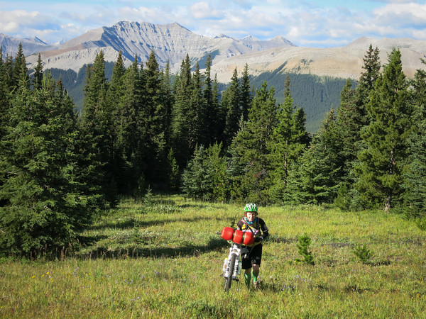
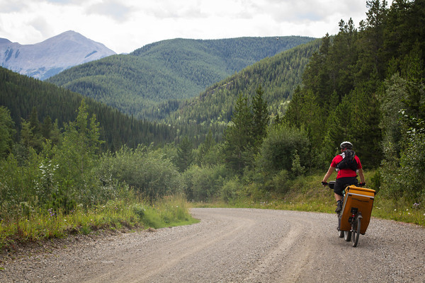
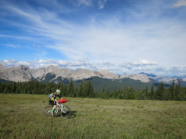
From there it was just some picture-perfect ridge riding for a while…

And then a wonderfully fun descent, totally rideable for Alex with the trailer even, as we turned down the Jumpingpound Trail rather than riding up Cox Hill (as tempted as I was).

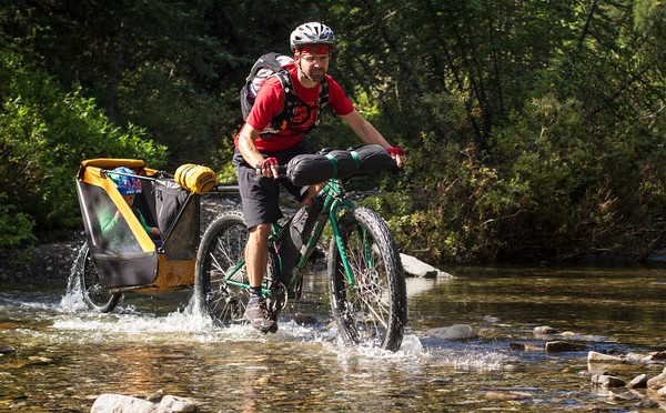
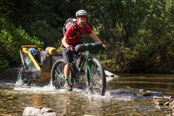
To regain the road we had to ford the mighty river, as the old pedestrian bridge was still out. Thankfully it wasn’t terribly mighty, and it was actually quite easy to ride across.

And from there it was largely downhill back to the car, hoorah!

Total trip distance: 33km (Day 1: 18km, Day 2: 15km)
Total elevation gain: 860m (807m of that on Day 1)
More details: We started and finished at the Dawson Recreation/Camping Area, where the Cox Hill trail joins the road. The road is currently closed to public vehicles beyond that point.

The bike-packing with toddler packing list:

Categories
canada general hiking moosling

Black Prince Cirque is a hike. A mosquito-ridden hike.

Mosquito-ridden it may have been, but at least it was scenic.

It began with a roadside bull moose, as we were on our way to the trailhead.

We set off, and the Moosling did a lot of hiking, until we hit the uphill. He was very interested in the river though, and made a few side trips to see if he could get into it.

Bridges were fun though, for trip-trapping over, and for throwing things off.

We reached the cirque, and Warspite Lake, and ate lunch while running around in circles being eaten by mosquitos.

And then on the way down there were pikas, and a lot more throwing things into streams.

Rating: A good toddler walk, except for the one longer uphill section where he was grudgingly carried.

Categories
bikes canada general moosling trip reports

Biking the Elbow Loop with a Chariot

The Elbow Loop is one of those rides I kept coming across in lists with descriptions like: “Classic K-Country Rides”. And in fact it is a classic – in the sense it comes from the days when mountain-biking was all about riding on rough dirt roads, back before the day when someone realised they could ride single-track, and that was actually a lot more fun.

With all that double track, we figured we may as well take the Chariot along. I’d never ridden the loop before. Alex had, but seemed to think it was worth doing again – and it was, in that it was one of the double-track rides around that’s possible to do with a Chariot. Otherwise, there are a lot of much more interesting rides in K-Country (although the scenery is quite nice, and maybe I’m just a little spoilt from living in the mountains now).

We headed out along the Little Elbow trail first, riding the loop anti-clockwise. After passing a few hikers we had the trail to ourselves for most of the climb up to Tombstone Pass. The climbing was pretty relentless, but we risked the perils of inertia and made one stop along the way so the Moosling could get out and throw rocks around (mostly at Mama).

The trail reports had threatened snow at the pass, but although there was a little hiding in the trees, the trail itself was clear. I’m increasingly having no faith at all in the trail reports out here.

Crossing Tombstone Pass

We didn’t spend much time at Tombstone Pass, but dropped down into the Big Elbow Valley, where the trail narrowed, and became a lot more like single trail (although still passable on the Chariot). At the same time, the scenery got a little more spectacular, and I could see why people would rave about the ride.

Descending into Big Elbow Valley

Some of the more interesting sections were found on this side of the circuit, and I was glad I wasn’t towing the Chariot – so I could zoom on the single track, and so I didn’t have to haul it uphill after the stream crossings. A couple of sections here the Chariot was walked, both uphill and downhill, but never for long.

Eventually we left the hills behind, and followed the river out along the flat. And along the flat. And along the flat. That interminable flat track, it eventually spat us out back at the carpark, and we were relieved, as we’d had enough of riding mountain bikes along flat rocky roads.

The Big Elbow River

Distance: From the campground carpark, the whole loop worked out to be a little over 42km
Elevation gain: About 850m of climbing. Basically it’s uphill for nearly 20km, to an elevation of about 2,230m, then mostly downhill for the 20km back home.
Chariot-ability: Mostly double track. A few sections narrowed to single trail, but it was always forgiving wide single trail that was easy to get the Chariot along. The creek crossings were numerous and interesting though, especially the rocky ones. And a couple of rocky downhill sections we opted to walk.
Rating: Nice views, fun if you’re bike packing through the area, feel the need to explore somewhere new, or have to pick an adventure that is Chariot/trailer friendly.

Categories
canada general snow

A backcountry birthday treat

As a birthday treat, I went out backcountry minus baby for the first time since being pregnant (well the timing was coincidental as much as anything, but it worked well as a birthday treat).

It wasn’t exactly a bluebird day, but there were buckets of fresh snow to play in. It was my first time out at Burstall Pass, and I discovered what a long way it is along the flat to get to just a few short turns. I’d renew my vow to avoid skiing to lakes, but I’ve the feeling the Tryst Lake chutes could be on the agenda some time soon, and they’re definitely nice and steep.

(For the record, it’s about 16km return with 450m elevation gain)

Categories
canada general hiking trip reports

Read’s Tower (a.k.a. Read’s scree slog)

In front of Mount Sparrowhawk in K-Country, there sits a little jutting lump of rock, covered in scree. I didn’t know beforehand that it was covered in scree, I just knew it was called Read’s Tower, and we were going to hike up it instead of Mount Sparrowhawk as it was supposed to lack the slightly dodgy-with-baby scrambly sections.

Spray Lakes views from Read’s Tower


It was completely lacking in dodgy scrambling, but the trail had plenty of steep and unpleasant dirt sections, and lots of the slogging variety of scree. Not the worst track in the world, but I certainly wasn’t hiking up it thinking “Golly, isn’t this a delightful track, lets go and have tea over by that large rock.”

Having a tasty lunch of sunglasses


At least the views were good, and it was a gloriously warm day, and we had the entire area to ourselves – apart from those pesky scenic tours helicopters, the place seems absolutely infested with them sometimes.

Looking up to Read’s Tower on the right and Mount Sparrowhawk in the distance


Elevation gain: 920m
Round trip: 6.8km
Height: 2,663 m