Categories
canada general hiking trip reports

Tent Ridge, finally!

Another hike we’ve been wanting to do for a while. We considered doing it dressed as pirates (no reason), but in the end went for normal hiking clothes.

It all starts with a lot of slogging up through trees, then up and into the valley surrounded by the horseshoe shaped Tent Ridge.

The boy did a good job of hiking up the hill, with the aid of his mountain climbing stick.

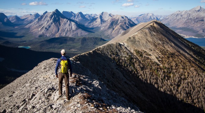
On the top of the ridge (on the east side, we were going clockwise) we stopped for lunch. Then Alex and the boy decided to avoid the scrambly sections ahead, and just head back down again.

Meanwhile, Lincoln and I headed onwards – straight up and over, the classy line.

Spray Lakes sat in the background, bright blue and full of sharks. We reached the enormous fridge on top of the first corner of the horseshoe, and were terribly sad when we found out that it had no icecream or cold drinks, and wasn’t actually a fridge at all. Or if it was, it was quite hard to open.

The views from the ridge really were amazing. Below is The Fist, which was kind of tempting to scramble.

Rounding the end of the horseshoe involved a bit of scree slogging, and then Lincoln peered over the ridge of eternal doom.

Below is the view back across to the east side of the ridge. And some ridiculous mountains and a very blue sky.

Things got quite talus-y for a while there, and then calmed down into an easy gentle ridge again.

We ran into another group of hikers just as we were about to drop down off the end of the ridge, and so there was a mutual exchange of jump shots.

And then the descent. Kind of muddy, with a few crashes, but otherwise successful.

Distance: 11km
Elevation gain: 750m

Categories
bikes canada general moosling trip reports

The annual Skogan pass family epic

Every summer since we grew our small person, we have biked up to Skogan Pass from Canmore. First time was when he was one. And now he is four. So we have done it *counts* FOUR times! (I am a genius)

It’s about a 45km round trip, with a fair bit of climbing. This was the first time he’s come close to participating in moving himself along though – which is good, as he’s starting to get heavy!

On the whole, he’s been spending most of his time on the trail-a-bike dangling with his feet in the air, rather than on the pedals. We came up with a solution for this later in the ride…

With the un-scenic and slightly un-official portion of the ride out of the way, we picked our way around the creek, and started riding uphill.

Enthusiasm and energy levels were a little low today. So thankfully the weather was nice, and there was a lot of food to distract everyone from the fact they were riding up an enormous hill.

About halfway up, the switch was made, and Lincoln started towing the wasp boy (he looks a lot like a wasp, with his legs all dangling down like that.

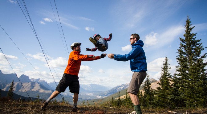
At the summit we ate some more, then had a brief game of child tossing (instigated by the child, who was most upset when we wouldn’t keep doing it). And then a roll all the way back down the hill.

We were part way down the hill when we came up with this brilliant duct-tape themed idea. Because what else do you use to solve the problem of feet that won’t stay on pedals?

After some initial unhappiness with the idea, the boy was fine with it, and he actually (finally!) started pedalling the bike. So, success! (The scrinchy face above is the result of eating a nutbar at a snack stop, not despair over having trapped feet.)

Hopefully next summer we’ll be making the transition to doing all of our bike trips with the trail-a-bike… or _a_ trail-a-bike at any rate, I’m not really sold on the one we have.

Categories
canada general

Run the Wild

My first rogaine in Canada! Well, Run the Wild is more than just a rogaine. Let’s call it an orienteering and rogaining and fun themed race of awesomeness.

We were handed the maps in three stages. First up was a section that was apparently based on an orienteering peg race? With no real orienteering experience, I had no idea what anyone was talking about. But it involved collecting ribbons at checkpoints, and if you were one of the first ten teams to some of the controls, you had to go off and collect an extra checkpoint, and therefore extra ribbons, and therefore end up with more points.

Section two was a trail run of sorts, but with checkpoints along the way, each with one of a series of connected name on them: Rod, Gail and Neil. The trick then was to work out the connection between the names. As an Australian rogainer, it was an easy connection to make from a well known story. All of the Canadian orienteering types were baffled. (They were the three Australians who invented rogaining – the awkward name comes from combining each of their names)

Then onto section three, which was the two map main rogaining part of the course. And we swept the entire course (i.e. collected every single checkpoint!). With 1hr15min to spare in a 6 hour race! This was largely due to Miles and his brilliant navigating – once we settled into the main course, we were bang on arriving at every single control.

There was a brief stop at checkpoint 99 for a “String-O”. Tie yourself to your partner, clip into the string, remove your watches, guess how long it will take you to complete the course. Winner is the team who finishes closest to their guess. Fun, and my counting was pretty bang on, we’d just guessed a time that was too hard to achieve – maneuvering through a field of boulders while attached to someone else is just as difficult as you might think it is.

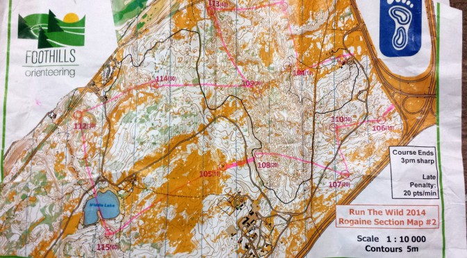
As we hunted down checkpoints, I was constantly baffled by the fine detail of the maps. I’m used to Australian rogaining maps, where you count yourself lucky to get 1:25,000 or 1:30,000 maps. I couldn’t get the hang of the 1:10,000 map, and just how much detail would be visible with the wacky 5 metre contours an orienteering notations (park bench… fallen tree… boulder… really!?).

Great fun though. And there was port. And delicious post-race food. And swag. And I won a tree! Although I lost my jacket :( So hopefully the tree will be able to protect me from the elements while I’m out running.

Categories
canada general hiking trip reports

Climbing the un-climbable mountain

Cascade Mountain isn’t so much un-climbable as un-climbed. It’s been shadowing my every move for years, continuously reminding me that I still haven’t scrambled my way to it’s summit.

So finally this autumn I proclaimed, enough is enough! I shall reach the summit of this magnificent mountain, even if I have to crawl there in a snow storm! (Or more accurately, wait until I finally have a day free with nice weather and not too much wind)

The levels of indecision were high in the morning though, and so by the time I hit the road with Lincoln, it was well after 11am. And we decided to bike to the trailhead despite this (on mountain bikes). And stop at Le Fournil Bakery on the way.

Then we rode the Legacy Trail, with Cascade Mountain sitting and watching us approach. But this time, we had a cunning plan. Also, this time we saw a grizzly bear wandering about below the trail as we got close to Banff – a lucky bear? It didn’t eat us, so perhaps.

After spending hours and hours riding up the Norquay switchbacks, we rode through the resort, then locked the bikes up at the trailhead and started out on foot at about 1.45pm. There really wasn’t a lot of running, more fast marching, as we gained as much altitude as we could as quickly as possible.

The Ampitheatre came and went, in an unimpressive blur. And then we were striking it out uphill through the trees, until there were no more trees, and we were adrift in a cairn-strewn field of talus.

I had a copy of the Scrambler’s Guide to Cascade Mountain with me. I may as well not have bothered, as the instructions were only obvious in hindsight. Between us both we worked out what seemed to be the most logical way to the top though. It’s not too tricky, so long as you pay attention and know roughly where you need to end up next.

There were plenty of the “inexperienced and ill-equipped” groups that are reputed to roam this mountain – they all seemed to be having a good time though, and none appeared to be in imminent danger of falling off the mountain, or taking any awesome shortcuts.

It didn’t take us too long at all to reach the final steep scree slog to the summit. And then suddenly – we were there! And the views were amazing, and there was barely any breeze, and the temperature was perfect, and what a good thing I hadn’t tried to do it on one of those windy days, it would have been miserable.

Following a suitable period for admiring the other mountains (Hello, I see you Assiniboine!) – and chuckling at Tunnel Mountain’s attempt to be a big mountain, just like it’s older brother Mount Rundle – we headed downwards again.

Glorious day, we even made it back to town just on sunset!

And now Cascade Mountain is no longer a taunting presence, but a pleasant reminder of a day well spent.

Distance: 17km on foot, 64km on bike (to and from the trailhead from downtown Canmore)
Max elevation: 3000m
Elevation gain: 500 on bike, 1560m on foot (there’s obviously some upping and downing in there, as we started at 1300m asl)
Round trip time on the Cascade trail: 4hr40min
Moving trip time on the Cascade trail: 3hr20min
Fastest known time for the Cascade round trip: I’m not sure, but I’m guessing under 3 hours total – maybe even under 2 hours? But I can’t find a record online.
Door to door round trip by bike and foot (including bakery stop): 8hr20min

Categories
bikes canada general trip reports

Riding 200km one sunny September Sunday

I took my Surly Karate Monkey, loaded it up with food and water, and headed out… at about 10am, because there may have been sleeping in, and disorganisation.

Along the Legacy Trail and into Banff. A stop at Wildflower Bakery you say? And to the grocery store – nutella croissants you say? I don’t mind if I do.

Then up Goat Creek towards Canmore, south on Spray Lakes Road for a mercifully brief stretch before heading to the west side of Spray Lakes.

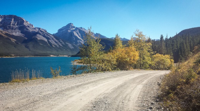
South and south along the deserted west side of Spray Lakes, then bike out through Mount Shark.

South at Engadine Lodge, down to the end of the road, and then north along Highway 40.

Then because it’s getting dark, home to Canmore via the 1A and Exshaw, rather than over Skogan Pass.

Thoughts of the ride…

  • Scroggin is inherently vulnerable
  • Wildflower Bakery is awesome
  • I like Goat Creek much better in this direction
  • Tether your GPS
  • Rotate your owl
  • If you’re feeling far too clean, riding along Spray Lakes Road on a busy Sunday is a great way to address this problem
  • We should go and bikepack/camp along West Spray – especially now when the campground is closed
  • I saw a bat!
  • It’s beautiful along here – especially when you consider the strip of dust hanging on the far side of the lake.
  • This is a bit spooky and deserted. I will sing loudly and yell a lot.
  • This service station is open!? I love icecream! I love cold drinks! All hail the end of water rationing!
  • Riding on asphalt is waaay faster than dirt roads.
  • You should start this ride earlier or bring better lights if you want to be able to ride over Skogan or Jewell Pass
  • A helmet light would be good to prevent roadside animals and noises being scarier than they have to be.
  • Please don’t eat me, barky dog!
  • I’m not sure if I remember how to be people any more.
  • What’s this? A warm plate of freshly cooked dinner, for me? I’ll take two!