Categories
bikes canada general hiking snow

Smuts Pass, Birdwood Traverse and Burstall Pass

We planned a grand adventure for the day – from Canmore, then out to Smuts Pass, along the slopes of Birdwood, and over Burstall Pass, then back to Canmore.

First of all to ride along the dusty roads, through biting headwinds, along rough gravel, by many cars.

We attached the magnificent velocipedes to a hidden tree, snacked and tied on some speedy shoes.

Beating through the vicious creek until the valley opened, we began our ascent to Smuts Pass, where the trees finally relinquished their grasp on our flesh.

There we found snow, and trod carefully for fear of getting our shoes dampened.

We looked on the magnificent Mount Smuts and pondered the difficulty of reaching her summit.

Far below lay the Birdwood Lakes, turquoise and marvellous in their alpine splendor.

Then a small traverse, through inches of snow. We thanked the footsteps of those who had travelled before us and made our work easy.

Onwards, and under the mighty slopes of Mount Birdwood, majestic and looming.

We trod carefully as we travelled through yet more snow, our traverse continued.

And then, peering backwards, we admired our footsteps, and the slopes of Birdwood, the marvellous Smuts, and the perhaps less marvellous and certainly oddly named Smutwood.

Then finally Burstall Pass lay before us, with just the slopes of Snow Peak to sidle along before we reached the final pass of our day.

The sidling was long, hard and snowy, but then finally safely over and done. We had reached Burstall Pass and were now on a veritable highway of slush, jogging downhill and back to the flat land below.

From there, the journey to the velocipedes was long, yet not difficult. Except for the large amounts of fatigue in our feet and legs.

As darkness fell we retrieved the velocipedes, attached glowing lights to them, and soared home with a favourable wind at our backs and starry skies overhead. It was glorious.

Distance travelled: 80km (velocipede), 27km (on foot)
Elevation gain: 1130m (velocipede), 1050m (on foot)
Max elevation: 2424m

The foot portion of the day:

Categories
canada general

Grizzly Ultra race report

At 50km, the Grizzly Ultra is barely an ultra-marathon. Which just goes to show how perspectives change – when you’ve started hearing all about other people who are out doing 300km+ trail races, 50km barely seems any sort of distance. Which isn’t the best mind set to fall into.

Despite having the best of intentions when I signed up for this race, I managed to yet again fail to train properly. I definitely got in a lot of long, slow runs, but apparently that wasn’t enough, and I really did need to get in some more shorter runs that actually involved some running.

I was noticing reticence on the downhills even just 15km into the race, and by the time I’d hit 30km, there was no doubt about it. My knees were unhappy, no part of my legs wanted to hammer down hills. Or on the flat really. They were vaguely accepting of hills, but mostly they were trying to convince me I should just go and lie down, and pulling out of the race early wouldn’t be such a bad idea. I told them to shut up, and tried to ignore their whiny complaints. Because there was nothing serious going wrong there, it was just a case of legs going “Waah, we’re tired, this hurts, we don’t like it, we’re hungry, are we there yet?”

So apart from that, I did actually manage to have fun. The first leg I ran with Lincoln, before he disappeared into the distance like a lanky mountain goat. Then I came across other people to chat to. Or to harass with my terrifying race outfit. Here I am, endeavoring to look as threatening as possible as I leap across the finish line.

After which I sat down for some time.

Distance: About 51.5km
Elevation gain: ~1450m
Time: 5hr32:30 (40 seconds slower than last year, 13 minutes slower than 2012, grrr!)

Categories
canada general hiking trip reports

Climbing the un-climbable mountain

Cascade Mountain isn’t so much un-climbable as un-climbed. It’s been shadowing my every move for years, continuously reminding me that I still haven’t scrambled my way to it’s summit.

So finally this autumn I proclaimed, enough is enough! I shall reach the summit of this magnificent mountain, even if I have to crawl there in a snow storm! (Or more accurately, wait until I finally have a day free with nice weather and not too much wind)

The levels of indecision were high in the morning though, and so by the time I hit the road with Lincoln, it was well after 11am. And we decided to bike to the trailhead despite this (on mountain bikes). And stop at Le Fournil Bakery on the way.

Then we rode the Legacy Trail, with Cascade Mountain sitting and watching us approach. But this time, we had a cunning plan. Also, this time we saw a grizzly bear wandering about below the trail as we got close to Banff – a lucky bear? It didn’t eat us, so perhaps.

After spending hours and hours riding up the Norquay switchbacks, we rode through the resort, then locked the bikes up at the trailhead and started out on foot at about 1.45pm. There really wasn’t a lot of running, more fast marching, as we gained as much altitude as we could as quickly as possible.

The Ampitheatre came and went, in an unimpressive blur. And then we were striking it out uphill through the trees, until there were no more trees, and we were adrift in a cairn-strewn field of talus.

I had a copy of the Scrambler’s Guide to Cascade Mountain with me. I may as well not have bothered, as the instructions were only obvious in hindsight. Between us both we worked out what seemed to be the most logical way to the top though. It’s not too tricky, so long as you pay attention and know roughly where you need to end up next.

There were plenty of the “inexperienced and ill-equipped” groups that are reputed to roam this mountain – they all seemed to be having a good time though, and none appeared to be in imminent danger of falling off the mountain, or taking any awesome shortcuts.

It didn’t take us too long at all to reach the final steep scree slog to the summit. And then suddenly – we were there! And the views were amazing, and there was barely any breeze, and the temperature was perfect, and what a good thing I hadn’t tried to do it on one of those windy days, it would have been miserable.

Following a suitable period for admiring the other mountains (Hello, I see you Assiniboine!) – and chuckling at Tunnel Mountain’s attempt to be a big mountain, just like it’s older brother Mount Rundle – we headed downwards again.

Glorious day, we even made it back to town just on sunset!

And now Cascade Mountain is no longer a taunting presence, but a pleasant reminder of a day well spent.

Distance: 17km on foot, 64km on bike (to and from the trailhead from downtown Canmore)
Max elevation: 3000m
Elevation gain: 500 on bike, 1560m on foot (there’s obviously some upping and downing in there, as we started at 1300m asl)
Round trip time on the Cascade trail: 4hr40min
Moving trip time on the Cascade trail: 3hr20min
Fastest known time for the Cascade round trip: I’m not sure, but I’m guessing under 3 hours total – maybe even under 2 hours? But I can’t find a record online.
Door to door round trip by bike and foot (including bakery stop): 8hr20min

Categories
bikes canada general hiking trip reports

Lake O’Hara – I think this might be paradise

A gloriously cunning plan came together at the last minute, after our original weekend plans were scuppered. I sat refreshing the Lake O’Hara website until I saw that someone had cancelled and there was a free night of camping for either Friday or Saturday night. I missed the first Saturday, and then a Friday spot, but was successful in snagging the next Friday spot that someone had cancelled – presumably because they didn’t fancy the rain-filled forecast.

Due to the afore-mentioned rain, we didn’t bother booking the early bus up. Instead we opted for the 3.30pm bus, and while the menfolk sat at home putting the final touches on packing (by which I mean, assuming I’d done a good enough job, and sitting around playing computer games) I set off from home on my road bike.

It wasn’t raining at all! Well, not at first. It was mostly uphill, and a bit headwindy, but it often seems to be in that direction. I’d allowed four hours, which is about what it took. Four hours and 95km later, I was slightly soggy but pulling into the Lake O’Hara trailhead parking lot, pretty sure that I had beaten the menfolk in their fancy car.

I stashed the bike in the trees, did a few laps of the parking lot to confirm they hadn’t somehow snuck by me, then sat and ate the rest of my food while I waited for them to arrive. Which they did. With some nice dry clothes for me, and thankfully with at least 10 minutes to spare before it was time to jump on the bus. I did a quick carpark change into dry hiking/running clothes, draped my stinky bike clothes artfully about our car interior to dry, then we leapt onto the bus.

The buses that run up and down the Lake O’Hara access road are big old school bus type things. Loud and roaring, they do the job without much grace, but a certain amount of jolliness.

At camp, we nabbed a site, got the tent set up and semi-assembled, then went prowling about. The boy wanted to find friends, while we wanted to go for a walk to the lake.

We managed to convince him to walk first, then he spent the rest of the evening in seventh heaven as a hoard of other small children descended on the camping area.

His new best friend was a fellow 4 year old, a Czech-Columbian girl named Kati. She was just as boisterous as him, and they had great fun running about in the rain and the mud.

We huddled in the tiny shelters to cook dinner. Our fellow campers were all lovely and friendly, and despite the cramped quarters it was a much more enjoyable experience than our recent Assiniboine stay. The rain showers passed, and we emerged to sit around the fire pit in the social area – chatting, and stepping in to prevent the children from getting too Lord of the Flies when necessary.

After a lazy sort of morning in the tent, we eventually got up and found that the morning was gorgeous and clear, and congratulated ourselves on winning the weather forecast lottery.

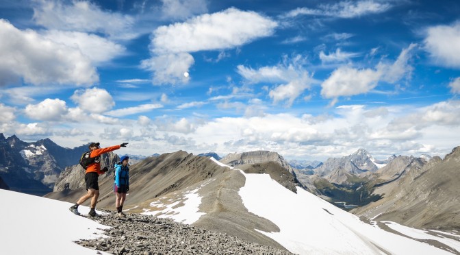
After a delicious and fulfilling breakfast of a Clif Bar, I set off to run the alpine loop while the menfolk went for a hike. I shot straight up to Wiwaxy Gap, trying to make up a little time after a late start.

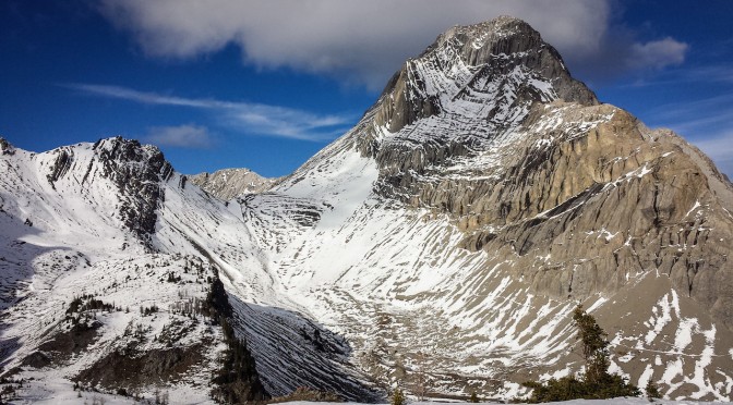
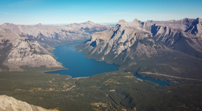
Then it was over to Lake Oesa, which I’d never seen before, and it was at about this point I began to realise just how beautiful this area was. We’d been up to Lake O’Hara before, but never much higher, and higher is really where it’s at.

From Lake Oesa, a trail through the scree lured me around to the Yukness Ledges Alpine Route.

I was surprised how much of the alpine routes were runnable. Although I spent a lot of time distracted by the scenery, and not running at all. And I couldn’t bring myself to put my camera away, which made running a little more awkward anyway.

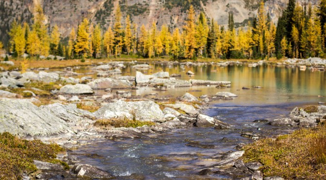
Then it was down to Hungabee Lakes, and through a little nest of lakes that had drawn herds of photographers to them like bees to some particular bright coloured and pollen laden flowers. It wasn’t just photogenic, it felt like a dream. It was the sort of place that made me just want to stop and lie down and gaze at the world in wonder.

And yet, I kept running. Up along All Souls’ Alpine Route, and a quick stop at All Soul’s Prospect.

Then down, down down, and as fast as I could go back to camp. There I tagged off Alex who took off on his own run.

The boy had already been out for a hike, so we sat and lunched, and he played with Kati. There was chatting, and relaxing in the sun, and then more food and lazing.

Alex made it back in time for us to catch the 4.30pm bus, so we jumped on it. Although it was running about 10 minutes late, I managed to retrive my road bike and be ready to start pedalling at around 5.20pm.

I had some lights for the bike. I wasn’t sure how good they would be, but as long as I didn’t dawdle too much, I figured I shouldn’t have to do too much riding in the dark. The up-side of riding uphill most of the way there though, was that it really was downhill nearly all the way home. And not raining! And reasonably warm! And basically a perfect calm, clear September evening. It was hero riding weather, and I enjoyed every pedal stroke.

I even made the 95km home without having to turn my lights on!

Categories
canada general hiking trip reports

North-nearly-over Ridge

Grandmothers are very handy for enabling quality adventuring time with Alex. So handy, that we took advantage of one more opportunity, and had a go at running Northover Ridge with Al and Lincoln.

This year the southern side of the lake trail had re-opened, with the flood damage largely repaired.

We did a slightly better job of picking a route around Hidden Lake this time (compared to last year), and flew up the trail above it to the scree beneath Mount Sarrail.

Sadly wildflower season was basically over by this time though, so we missed out on the gorgeous splashes of colour. There are some advantages to going slightly later in the season though – especially with the amount of snow that still remained on the ridge!

We ran around Aster Lake to the south – which was much drier than the northern shores, hurrah.

As we hiked up towards Warrior Mountain, I tried to take a photo of Aster Lake. Somehow I managed to turn on this weird postcard mode – I have no idea how it happened, or where the setting for it is, or even how I managed to turn it back to normal photo mode really.

But from there on, it was just scree, scree, scree, scree…

Scree, scree, tarns and scree.

Scree, scree, scree, people, tarns and scree.

Until finally we hit the ridge. Where it was quite cold and windy! Actually, mostly windy.

But still breathtakingly beautiful of course.

We trotted along, stopping for photo breaks, and to throw snowballs.

It was around this point where we had an epic battle with a wizard. We distracted his dragon while Al and Lincoln ran off to the end of the ridge. But Alex and I were unable to defeat him, and thus made a strategic retreat, luring his attentions away so that the others could successfully make it down via Three Isle Lake.

We turned back the way we had come, which had the advantage for Al and Lincoln of a car coming around to pick them up at the end, and for us of seeing what it’s like to descend on the anti-clockwise loop. A completely different trail! Well, obviously not literally a completely different trail, but a very different feel.

Back to the car, another awesome day in the mountains where we weren’t defeated by any wizards. Legs are a bit sore though, and feeling quite hungry.

Distance: 35km (For going clockwise around the loop, getting nearly all the way to the end of the ridge before turning back)
Elevation gain: 1850m