Categories
bikes canada general moosling

Recovering in Revelstoke

The Singletrack6 madness was followed by four days of relative relaxation in the Revelstoke campgorund. Suffering from the after effects of heat exhaustion (walking hurt my stomach?) I didn’t get an awful lot of riding done. There was a lot of lazing and reading. But of course a little riding.

First on Frisby Ridge…

Then I took the boy out on the Macpherson Trails while the others actually went for a proper ride. He’s still riding pedal-free, but is getting better and better on his run-bike. He’s quite the cautious descender though – no madcap rolls down anything and everything for this boy.

Then there was an aborted attempt at Keystone Standard Basin. I’d finally recovered from the heat exhaustion, but bonked on the first hill and couldn’t understand what was wrong with me. Struggling on, eventually it got so bad that I could barely walk my bike along, and had to have a lie down. Once it occurred to me to eat the rest of the food I had with me, I magically felt fine, but decided heading back to the car probably wasn’t a bad idea. Apparently my body wanted about 10 times the calories I’d fed to it (although I’d spent most of the morning eating).

Categories
bikes canada general moosling trip reports

Bikepacking Jumpingpound Ridge

With a couple of sunny days at our disposal, a new set of bike bags for Alex finally complete, it seemed about time for an overnight bike adventure.

We’d been hoping to do a big loop from home and out into K-Country, via the Elbow loop. It’s still in poor shape following the floods though, so instead we opted for good old Jumpingpound Ridge, where the camping is free and the views can’t be beaten.

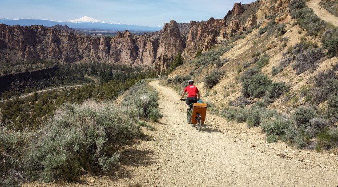
The road is still closed to cars, hurrah, and so we had a quiet ride out, much like last time.

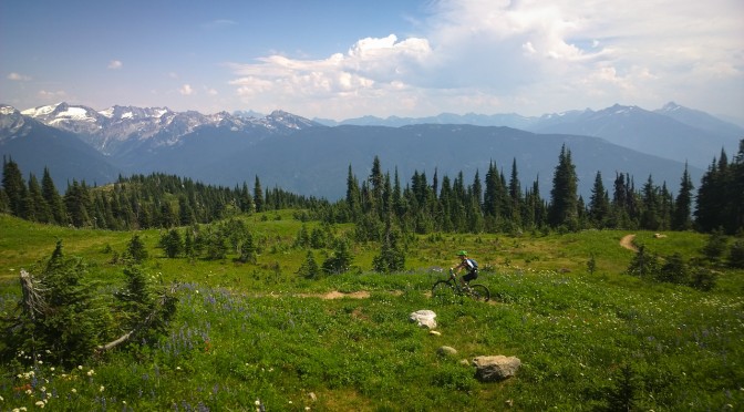
This time we were riding early enough to hit wildflower season though, which was nice.

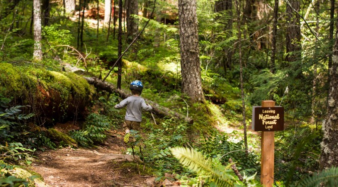
Once we hit the trailhead for our path up to the summit though, the flowers disappeared and the boy was kicked out of his trailer to walk up. Some genius had placed geocaches every 200 – 300 metres along the path. Usually this would annoy me, but on this day, it was perfect bait to lure on a small boy who started to get a little fed up with jumping over roots.

The last push up to the ridge over, we settled in just below the summit to cook dinner in the same spot as last time. Last time it was a bit cold, with a wind picking up that was bringing rain with it. This time it was eerily still, and swarming with mosquitos.

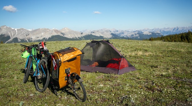
We ran around in circles, slapping and stomping as we enjoyed our dinner and the views. The mosquitos weren’t actually terribly bitey, most of them just hovered in confusion, not sure what to do with the vast expanses of delicious food that had turned up before them. They were a good incentive to get the tent set up though, which we did, piece by piece, in between running around in circles to shake off the clouds of mosquitos (except for Alex, who was for too dignified for such behaviour).

We didn’t bother with the fly on the tent, as the forecast was good, and it was easy to keep an eye on any incoming weather from where we were. We lay in the tent, and eventually switched from mosquito hiding and sky watching, to actual sleep.

A few storms rolled around on the far edge of the horizon overnight. We heard low rumbles of thunder, and watched lightning flashing in the distance. But the sky above us stayed clear, and filled with stars, and the temperature dropped enough to scare the mosquitos away.

The next day dawned wonderfully clear and warm. I watched bits and pieces of the sunrise from the tent, occasionally sticking my head up to acknowledge the different colours banding along the horizon.

As tempting as it would have been to keep lying in the tent, the sun was starting to shine on us with intent, and we had a 3.5 year old in there with us, who is quite insistent that if the sun is up, he should be up.

It was still a lazy and meandering sort of disassembly of camp. There was tea to be drunk, and gear to be thoughtfully rearranged in new bags, as we meditated on the optimal arrangement for the future.

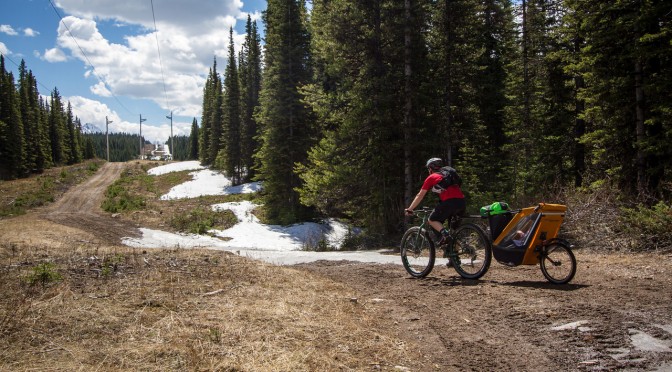
On the descent we found just one surprise drift of snow – not too bad if you’re just out for a day trip, but a small challenge to get around with fully loaded bike and trailer. That was nothing to the next challenge though. As I stopped to photograph Alex coasting down a section of trail, and then off into the distance, put the camera down – and then the singletrailer exploded! The wheel bounced off down the hill in a most poetic fashion. Actually, there wasn’t so much an explosion, as just the wheel coming off and bouncing away. Which did cause Alex to stop pretty quickly.

Here the boy looks despondent as Alex re-seats the bearing into the wheel so it could lock on properly. No rocks were harmed in the making of this photograph.

The final hurdle was the fording of the de-bridged river, which was flowing just a little higher than last year. I tried riding it, and ended up falling in. Which was fine, as I’d been riding in sandals all weekend, due to a forgetting-I-had-flat-pedals-on-my-bike-still incident. After seeing my less than stylish crossing, Alex opted to just walk across as well. I went to throw him my sandals for the attempt, and one fell short, and started floating away downstream. Cold footed lurching and squealing ensued, as I rescued the errant sandal and returned it to Alex.

The rest of the ride passed without incident, and we even made it back in town in time for the Canada Day parade (which was apparently too noisy, so we didn’t stay for the whole thing anyway).

Total trip distance: 33km (Day 1: 18km, Day 2: 15km)
Total elevation gain: 860m (807m of that on Day 1)
More details: We started and finished at the Dawson Recreation/Camping Area, where the Cox Hill trail joins the road. The road is currently closed to public vehicles beyond that point. And we took the trail directly beneath the summit to reach the ridge. Our packing list was much the same as last year, but with no diapers and more spare clothes/underpants for the boy. We did take less water, and now we both have fancy Porcelain Rocket bike bags, everything is much easier to carry.

Categories
bikes canada general moosling trip reports

Scouting Elk Pass

My next cunning plan was to ride my bike from Canmore to Fernie. But part of this plan involved convincing someone else to come with me, for at least part of the journey. For company, and so the bears would have someone else to eat.

The only difficulty was that the person who seemed most likely to come was being told that Elk Pass was under four metres of snow, and the whole expedition was foolhardy madness. We would be starting our joint journey at the Elk Pass trailhead. Elk Pass is the highest point between Kananaskis Lakes and Elkford, but if it was thoroughly under snow, there could be at least 10km of snow-slogging between us and the rest of the lower altitude (and hopefully dry) trail.

And so I had a scouting mission to undertake. Above is the view from the Elk Pass trailhead five days before we intended to set out. It wasn’t looking terribly promising.

But in the end, it wasn’t actually that bad. There was compacted snow on the trail, thanks to the cross-country grooming that takes place all winter long. But there were also a lot of dry and muddy patches.

The bridge I’m standing on to take a photo of myself? With a foot of snow on it? Five days later it was totally snow free.

But then, there were a few fairly epic snow patches too. Even towing the singletrailer, Alex fared better than I, with his big fat Krampus tyres.

But then we hit the powerlines, and everything was great! For a while. Then the trail was a perfectly compacted mass of slushy warm snow, mud and puddles of water, so we cycled along through the brush at the side for a while.

Picnic table at the summit of Elk Pass!

I went for a walk, found a good deep puddle of icy water, and tested my new goretex socks in it. Success! They’re absolutely wonderful. Shoes absolutely waterlogged and squelching with icy cold snow melt, feet toasty and warm within. Probably a bit stinky, but who cares so long as they’re warm! My new favourite piece of gear.

The boy spent some time throwing snowballs at everyone and everything, we napped in the sun for a while, and then battled the even mushier snow to descend back down to the car.

Mission successful. It definitely shouldn’t be too hard to get over the pass, the snow was melting like crazy, so things should be even clearer by the end of the week. And starting in the early morning will hopefully mean frozen mud and snow, much easier to ride on.

Categories
bikes general moosling travel trip reports

Riding bikes in Oregon – Part 3 (The rest)

Next up after Smith Rock was Peterson’s Ridge, near a little town called Sisters. After the Three Sisters series of volcanoes nearby. Which begs the questions “Why is it always Three Sisters, not Three Brothers?” But google confirms that it is sometimes Three Brothers, just less often.

We’d been told Peterson’s Ridge was a must-do ride, with great views. I’d vaguely assumed it must be on a ridge, and so would have awesome views. This was all lies and trickery. The trails was very nearly entirely flat, and was 95% in the forest, with views of nothing but trees. Pictured below is the “view” at the “summit”.

It is quite a nice view. The snow-capped volcanoes are very pretty. But we had to stop and look at it, as you could only see it for a few metres. On the plus side, there was a picnic table and a chipmunk there, and a big rock to sit on so as to promote greater enjoyment of the View.

It was an ok trail. Perfectly fine. But just don’t go into it expecting a ridge, or great views, or particularly thrilling riding.

Next up, I convinced Alex that we should go and ride Mrazek. And that was fun riding. Gradual uphill over many kilometres. Still not much in the way of views, although it felt like there really should be, and nearly would be at a few points. Just one really technical rocky section. Otherwise it was very much like a flatter version of Frisbee Ridge in Revelstoke. A nice consistent climb uphill, but then fantastic fun once you turn around and point your bike in the other direction – the sort of trail guaranteed to have Finn whooping and hollering at Alex “Faster Papa, WHEEEE!”.

The final big ride was the McKenzie River Trail. We weren’t sure if the single trailer would make it over some of the technical riding higher up on the trail, so we decided to do an out and back ride starting from the lowest point of the trail.

And for all that we were following a river upstream, it really didn’t feel like we were going uphill at all. The trail meandered through ferns and mossy trees, and the river burbled happily.

Everything was green.

We even released the Kraken from his trailer to go for a run.

Crossing all of the trail bridges got a little tiresome though. And so, when about 10km along, we reached one where the trailer would not fit, and instead jammed, we were pretty happy to turn around and head back.

I’m sure the upper part of this trail might be really fun, we hardly rode any of it. And it was quite pretty. But just a little boring (sorry McKenzie River trail).

And so ended our Oregon bike adventure. Well nearly. I went out alone the next morning on the local Bend trails and rode a really fun and fast loop, before jumping into the car and driving until we got to Canada. We camped the night; the next morning it started to rain on us, and by the time we got back to Canmore, our bikes were coated in ice, our deck had a foot of fresh snow on it, and biking in sunny 25oC weather was nothing but a distant memory.

Categories
bikes general moosling travel trip reports

Riding Bikes in Oregon – Part 2 (Smith Rock)

Turning off the highway and driving the final few kilometres to Smith Rock began an exercise in longing for my climbing gear that lasted until I began to realise that it was actually pretty fun to be riding here too. Smith Rock is one of THE North American rock climbing destinations. Birthplace of sport climbing? Maybe. Spectacular rock and views? Definitely.

The boy rode his bike for the first few hundred metres, then decided he’d had enough, and for the rest of the day it was just helping Alex with his resistance training.

Alex tried to sell me on the idea of starting off with an easy loop around the river trail, but I wasn’t having any of it, so instead we immediately started heading uphill, where the views are. Although of course this did involve initially dropping down from the parking lot, to the river, and then having to start the climb from the valley bottom.

We set out with a route description from an old mountain biking book. This book suggested that the trail we were headed for, Burma Road, was a pretty burly climb. Thus far, nothing we’d rode in Bend seemed to involve any climbing at all. So we may have underestimated this threat. It was indeed a burly climb, particularly with a singletrailer. Even without – there were pitches of loose, steep trail that weren’t easily rideable.

After that, things got a little saner though. We’d gained a lot of elevation already, and were spat out onto some doubletrack that was a more sensible gradient (something between the climb to the Pass in Canmore, with occasional touches of the Quaite Valley trail thrown in for good measure).

And then views! For some reason Alex was feeling a little tired by now, and felt like sitting down in the shade and eating some lunch.

From this point the route in the book described dropping down on fire road for no reason before climbing back up more fire road to reach Grey Butte. Alex was not enthusiastic about this option, so after lunch I did some scouting, and found some singletrack headed towards Grey Butte that was deemed acceptably not-uphill.

It turned out to be a great choice. In fact the only flaw to this piece of trail was that it was hard to avoid looking at the views. And when you did look at the views, it was hard to avoid falling down the side of the mountain. Aside from that, it was lovely. We turned around once we reached the butte though, rather than trying to ride around or up it, and headed back towards Smith Rock. Where there was more difficulty trying to look simultaneously at the view, and the narrow strip of dirt we were trying to balance on.

From here it was all smooth sailing back to the car, except for the one steep section of Burma Road, where the boy was booted out of the singletrailer. I walked him down the hill in stages, while Alex man-handled his bike with empty singletrailer down the hill.

But after ferrying my bike ahead through one piece of trail, I stopped after hearing an odd noise. After looking around, I realised the source of it was a little rattle snake sitting on some rocks just in front of me, rattling in a cranky kind of fashion. He was close enough for me to reach out and touch, and seemed so small as to be adorable rather than threatening (at least compared to Australian snakes I’m used to), but I backed away anyway, and advised Alex he’d be better off taking the high route at this point, as the low route had an irritated rattle snake on it.

And then it was time for icecream!

Distance: 17km return
Elevation gain: 660m