My first rogaine in Canada! Well, Run the Wild is more than just a rogaine. Let’s call it an orienteering and rogaining and fun themed race of awesomeness.

We were handed the maps in three stages. First up was a section that was apparently based on an orienteering peg race? With no real orienteering experience, I had no idea what anyone was talking about. But it involved collecting ribbons at checkpoints, and if you were one of the first ten teams to some of the controls, you had to go off and collect an extra checkpoint, and therefore extra ribbons, and therefore end up with more points.

Section two was a trail run of sorts, but with checkpoints along the way, each with one of a series of connected name on them: Rod, Gail and Neil. The trick then was to work out the connection between the names. As an Australian rogainer, it was an easy connection to make from a well known story. All of the Canadian orienteering types were baffled. (They were the three Australians who invented rogaining – the awkward name comes from combining each of their names)

Then onto section three, which was the two map main rogaining part of the course. And we swept the entire course (i.e. collected every single checkpoint!). With 1hr15min to spare in a 6 hour race! This was largely due to Miles and his brilliant navigating – once we settled into the main course, we were bang on arriving at every single control.
There was a brief stop at checkpoint 99 for a “String-O”. Tie yourself to your partner, clip into the string, remove your watches, guess how long it will take you to complete the course. Winner is the team who finishes closest to their guess. Fun, and my counting was pretty bang on, we’d just guessed a time that was too hard to achieve – maneuvering through a field of boulders while attached to someone else is just as difficult as you might think it is.

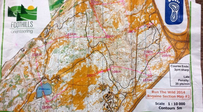
As we hunted down checkpoints, I was constantly baffled by the fine detail of the maps. I’m used to Australian rogaining maps, where you count yourself lucky to get 1:25,000 or 1:30,000 maps. I couldn’t get the hang of the 1:10,000 map, and just how much detail would be visible with the wacky 5 metre contours an orienteering notations (park bench… fallen tree… boulder… really!?).

Great fun though. And there was port. And delicious post-race food. And swag. And I won a tree! Although I lost my jacket :( So hopefully the tree will be able to protect me from the elements while I’m out running.