Categories
canada general hiking moosling trip reports

Pigeon Mountain

Picking hikes in spring is always a bit tricky. Trails have started to dry, snow has kind of melted – but there are still snow patches and ices lurking about the place. It was really a bit too early to try hiking Pigeon Mountain. Based on what you could see from the road, Alex was convinced it would be dry – I was a little more dubious, but figured a little snow wouldn’t kill us.

We set off fairly late – it was afternoon by the time we started hiking. The day was sunny and warm, but slightly unsettled. I was slightly hungover, having been drinking last night while enjoying the Missed Connections improv show at ArtsPlace, and then wandering out to dance to an 80s cover band and engage in some ironic head banging (it may have been ironic but it still gave me a sore neck the next day).

It didn’t take us long to hit snow – unsurprising. It didn’t take long for my slight hangover to fade either. Thankfully.

It’s five kilometres up the road before you reach the turnoff for the Pigeon Mountain trail. If conditions are good (that is, the road isn’t covered in snow) then it’s worth bringing bikes to ride up to this point, if only for the coast back downhill again.

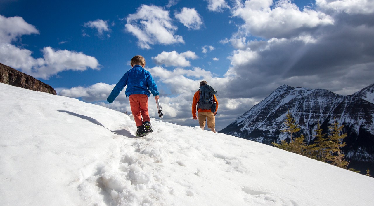
Having turned off onto the Pigeon Mountain trail things got icy in the trees and I finally caved and put on my spikers – if only to help Finn along. But the section through the trees doesn’t last long, and then suddenly we were out and into the alpine, above the treeline and finding huge stretches of dry trail again.

Dry trail that was climbing steeply, and covered with the huge herd of bighorn sheep. There were about 40 of them, mostly young looking, and carefully keeping out of our way.

We stopped for a brief lunch, then continued onwards and upwards, and it got windier and windier. Light saber battles unfolded across the scree fields. Rock sabers were wielded.

In the end we gave up on reaching the summit. Travelling through the snow had been slow, the wind was strong, and the daylight wouldn’t last forever. We went up to the saddle below the summit, and tried to pretend it was just as good. 6.8km in, it would still be a big return trip for an early season hike on small legs.

One of our party set off alone, aiming to make it to the summit without the aid of oxygen. The rest of us began the descent to base camp.

The clouds made empty threats, finally managing to cover up the sun but nothing more. Descending through the snow was not as fast as we’d like, and our shoes were getting wet – another spring hike where we’d underestimated how waterproof we should be. No bears on the way down, just more melting snow and out of tune singing.

Back at the car without injury six hours later, adventure completed. Success! Oh, except for the tick we found in Finn’s hair that evening – ew, ew, ew.

Distance: 13.6km
Elevation gain: 883m

Categories
bikes canada general hiking moosling trip reports

Pigeon Mountain (lacking in pigeons since 1858)

Pigeon Mountain has been hovering on our radar for a long time – it sits just next to Skogan Pass, so we’ve travelled past it plenty of times, but have never quite made the turn up towards the summit. It was a warm day for November, and without too much snow on the ground, we thought we may as well use this trip as a good shoulder season excursion.

After cheating and driving to the trailhead, we unloaded the bikes and Chariot, and started the slog up alongside the power-lines. There were a couple of other random hikers about, but the carpark had been overwhelmingly full of hunters. We passed a few on the trail; bow hunters who had bagged a bighorn sheep.

We managed to cover 3.5 km or so before the snow on the trail started to make traction impossible, so gave in and stashed the wheels in the trees.

Above the treeline and trudging uphill, with an old-school toddler carrying device – shoving them in the space between your back and the backpack

Another kilometre or so and we reached the turnoff, taking us up single trail, climbing a spur until we were spat out above the treeline and into the wind. From there on the trail wasn’t so well defined. There was a fantastic choose-your-own-adventure set of trails to follow through the snow though…

Follow the sheep trail. Turn to page 63. You have fallen into a wind drift and can’t get out. You starve to death before summer comes.
Follow the lower human trail. Turn to page 48. The trail disappears over the edge of a cliff. You fall to your death.
Set your own tracks across wind slab. Turn to page 38. The wind slab holds for the first twenty metres, but suddenly gives way, and you are trapped in postholing hell.

Lunch!

We managed to make our way through the perilous choose-your-own-adventure section, and reached the ridge, where the wind had kept the snow pretty thin on the ground. Surprisingly, the wind swept ridge was also rather windy.

Onwards and upwards

We were not alone – hoards of bighorn sheep around. The whole area will be under seasonal closure from December 1st, as it’s a breeding ground for the bighorn sheep.

It was easy walking to the summit and after snacks and photos at the summit cairn, we shook our fist at the sun, which had just disappeared behind a bank of clouds that had been hugging the mountains to the west of us, and then we scarpered back down the mountain.

Thanks to the bike-stashing effort, we made it back to the car a full five minutes before sunset (with the added benefit that we weren’t driven insane by having to walk down a road next to a power-line for a full five kilometres).

Oh, and as an added bonus, here is a link to the song we both had stuck in our head all day long.

Distance: 16.5km
Elevation gain: 960m
Summit altitude: 2394m