Categories
canada general moosling snow trip reports

Elk Lakes Cabin

It’s been such a long time since we’ve been out for a winter hut adventure. Nearly five years! So we (I) decided that to avoid having another winter drift away, it would be a good idea to start getting organised, and so the Elk Lakes Cabin idea was born.

I’d cycled past there last year, as I headed south to Fernie, but hadn’t actually checked out the hut. But I knew it was there somewhere, four or five kilometres beyond the groomed Peter Lougheed Provincial Park ski trails that take you to Elk Pass.

The three of us had a disorganised morning, sleeping in, then slowly getting everything packed and loaded into the car. Somehow this all took much longer than expected, and by the time we arrived at the Elk Pass trailhead it was after 1pm.

“Plenty of time” we said to ourselves… then “well, we have headlamps”.

As we set off we realised it was much colder than we’d been expecting. It’s sometimes hard to keep warm while skiing at small child pace too. After a couple of kilometres the small child was inserted into a sleeping bag and loaded into the pulk we had borrowed, and we set off at a more determined pace.

We’d headed along the Hydroline trail to Elk Pass, thinking we had a better chance of being warm up there – maybe we’d even find sunlight! And we managed to get a few minutes of sunlight before it disappeared behind the mountains for the day, but then the temperature just kept dropping.

Beyond Elk Pass it’s just backcountry skiing. There was a bit of a skier set track for the first kilometre or two, but it was much harder work to tow a heavily laden pulk through. Or so Alex tells me.

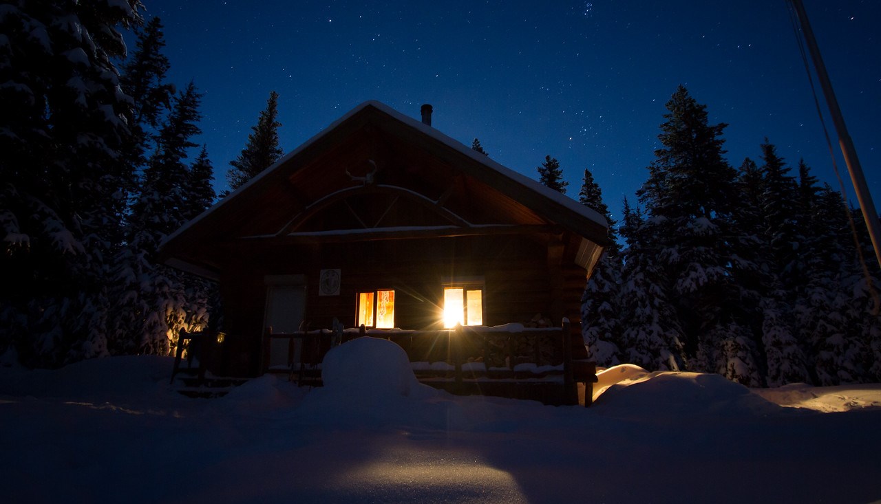
Theoretically this section is downhill. In reality, it didn’t feel very downhill, except for the final section just before you drop down onto the meadow before the hut. And by the time we reached that point, it was properly dark, headlamps-on skiing. Which was thoroughly exhilarating given the strength of our headlamps.

As we reached the meadow, we descended into a lovely cold pool of air. Alex’s thermometer was reading -25oC or so. My hair and jacket had gathered a thorough coating of white frost, and we kept moving, hoping that the hut was magically warm.

The hut was not magically warm. The combination lock on the door was frozen shut, and took some convincing to unlock, and then we were on a mission to build some fire and raise everything to a more reasonable temperature. Dinner was cooked, port was drank, and we sat down to play a family game of Settlers of Catan before bed. Finn had convinced us to bring it along – I’d taught him how to play the week before, and he’d developed an immediate obsession.

An early night to bed, we had more hut-guests arrive around midnight. They eventually settled down, and when we awoke the next morning (at 8.45am, a perfectly reasonable time) we discovered that 3 of the 4 of them were Australian, and very friendly hut-mates.

Our mission for that day involved nothing more than skiing back out again, but what with another game of Catan to play, and a slow breakfast, and then slowly packing, it was after 11am by the time we were on our way. Thankfully it was a bit warmer now, and the sun was shining!

We convinced Finn to ski across the meadow, then threw him into the pulk for the rough climb up to Elk Pass. We spent most of the climb singing loudly.

On reaching Elk Pass we snacked, booted Finn out of the pulk, removed skins, and started the ski down. Which was a lot of fun! Some sections were slightly ridiculous with no grip, but still possible.

As we pulled into the carpark, having just flown down the last hill, Finn’s conclusion was, after yelling “YAHOOOOO!” most of the way down the hill: “Mama, that was the best adventure ever, that was such a fun adventure!”

Distance: 10km (from Elk Pass trailhead to Elk Lakes Cabin)
Elevation gain: 240m (each way)
Time: 4.5 hours to the hut, 4 hours back to the car

Categories
bikes canada general moosling

Autumn and the Little Elbow River

We have been wanting to ride the Elbow loop again for a while now, but with the conditions on the Elbow River side still a little wild, we decided we may as well day trip out and back on the Little Elbow River side. My dodgy knee was hurting after getting over-excited and over-doing it, but with the dirt season nearly done, it was difficult to say no to a bike ride.

That first bridge is still out though. Wading through an icy cold river is better than coffee for a Sunday morning wake up.

We waded back and forth with bikes and offspring, successfully avoiding throwing anyone into the river.

A slow and gradual climb uphill followed. Certainly slow; not always gradual. Yellow leaves and snacks ensued.

Near the high point of the trail we hid our bikes in the forest and hiked out to the Tombstone Lakes. They were certainly lakes, and I wouldn’t hear it if anyone tried to tell me they were anything other than lakes. The fish swimming in them were certainly not an optical illusion. Sadly no photographic evidence of the lakes will be presented at this time.

Then a turn around, we hiked out again, retrieved bikes, and rolled most of the way back down the hill.

Not pictured is the two hours after the last photo was taken, when we were nearly at the bottom of the hill and Alex realised the (new, purchased after our old one died) GPS had come off its mount. He rode all the way back up to look for it while Finn and I played, then Alex came back and was cranky because he hadn’t found the GPS.

Story update: 6 weeks later and the GPS still hasn’t magically turned up. I think we may have to buy a new one :(

Categories
canada general hiking moosling

West Wind Pass

Hiking adventure!

West Wind Pass is just 5km return, but a nice taste of Kananaskis hiking. You get some of the views, and none of the scree. Perfect for flat-landers who still don’t have the hang of hikes with huge elevation gain, and perfect for boys who are declaring loudly to all and sundry that they don’t want to go up a mountain, and they just want to play minecraft/lego.

We had a short picnic session at the pass, re-enacted the scene from the Lion King (I’m very tempted to borrow another baby and come up and try this another time, when the light is a bit more suitable).

Back down above Spray Lakes…

Before heading home we made a quick diversion to this lovely mossy patch, which is a few hundred metres from the road on a nearby trail. It’s one of my favourite close-to-the-road spots in Kananaskis.

Categories
bikes canada general

Kananaskis wanderings

A lazy morning, then I wandered out with a loaded bike, and pedalled up the Spray Lakes Road.

I hadn’t decided quite where to go, but ended up thinking of a Spray River/Goat Creek loop… but when I got down to the Spray River turn-off, I realised that the wildlife closure had come into effect a couple of weeks ago.

Change of plans! And so I decided to try and push through the Mount Shark area – which is exactly where the Tour Divide route goes. Up until then, there’d barely been any snow. As I got closer to Mount Shark, there was quite a bit of deadfall, and then more and more snow.

At least the snow made for good pushing practise.

It was unsurprisingly deserted, and I didn’t come across anyone on my travels until I got out onto the Spray Lakes Road again. At which point I was suddenly flying along the nice clear road.

After some early snow, it turned out to be quite a nice day. I finished up with a foray down Goat Creek, which was rideable, but a bit muddy still.

And that was the Karate Monkey’s last big adventure before it was due for partial dismantling and the build up of my Triton mega titanium adventure bike!

Categories
canada general hiking trip reports

North-nearly-over Ridge

Grandmothers are very handy for enabling quality adventuring time with Alex. So handy, that we took advantage of one more opportunity, and had a go at running Northover Ridge with Al and Lincoln.

This year the southern side of the lake trail had re-opened, with the flood damage largely repaired.

We did a slightly better job of picking a route around Hidden Lake this time (compared to last year), and flew up the trail above it to the scree beneath Mount Sarrail.

Sadly wildflower season was basically over by this time though, so we missed out on the gorgeous splashes of colour. There are some advantages to going slightly later in the season though – especially with the amount of snow that still remained on the ridge!

We ran around Aster Lake to the south – which was much drier than the northern shores, hurrah.

As we hiked up towards Warrior Mountain, I tried to take a photo of Aster Lake. Somehow I managed to turn on this weird postcard mode – I have no idea how it happened, or where the setting for it is, or even how I managed to turn it back to normal photo mode really.

But from there on, it was just scree, scree, scree, scree…

Scree, scree, tarns and scree.

Scree, scree, scree, people, tarns and scree.

Until finally we hit the ridge. Where it was quite cold and windy! Actually, mostly windy.

But still breathtakingly beautiful of course.

We trotted along, stopping for photo breaks, and to throw snowballs.

It was around this point where we had an epic battle with a wizard. We distracted his dragon while Al and Lincoln ran off to the end of the ridge. But Alex and I were unable to defeat him, and thus made a strategic retreat, luring his attentions away so that the others could successfully make it down via Three Isle Lake.

We turned back the way we had come, which had the advantage for Al and Lincoln of a car coming around to pick them up at the end, and for us of seeing what it’s like to descend on the anti-clockwise loop. A completely different trail! Well, obviously not literally a completely different trail, but a very different feel.

Back to the car, another awesome day in the mountains where we weren’t defeated by any wizards. Legs are a bit sore though, and feeling quite hungry.

Distance: 35km (For going clockwise around the loop, getting nearly all the way to the end of the ridge before turning back)
Elevation gain: 1850m